Poulaphouca Dam creates one of Ireland’s largest reservoirs, covering approximately 20 km2. The reservoir captures runoff from the steep, mountainous Upper Liffey catchment in the Wicklow Mountains. It is fed by the River Liffey, which rises at Kippure, and by the King’s River, which rises near Turlough Hill.
The reservoir is operated within a normal operating band, primarily to support the safe operation of the reservoir and its associated concrete dam. Reservoir management also takes account of dam safety, flood risk and the potable water needs of Dublin.
During the prolonged periods of heavy rainfall experienced this winter, Poulaphouca Reservoir played an important role in slowing the movement of water through the River Liffey catchment. By storing large inflows from the Wicklow Mountains, the reservoir helped reduce the volume of water moving downstream through Kildare and Dublin City towards the sea.
From October to mid-January, reservoir levels were carefully managed to slow downstream flows and bring the reservoir down to its low winter level. In late January 2026, three intense rainfall events occurred within a single week. The most intense rainfall in the Upper Liffey catchment was recorded on 27th January, when 100 mm of rain fell at Kippure and 80 mm fell at Turlough Hill.
These prolonged rainfall events led to substantial inflows into Poulaphouca Reservoir from the Wicklow Mountains. The reservoir attenuated these inflows by storing large volumes of water, helping to minimise downstream river flows and reduce flood risk along parts of the River Liffey through Kildare and Dublin City.
This winter, the timing, intensity and geographic pattern of rainfall across the Liffey catchment, together with the preceding catchment conditions, meant that storage at Poulaphouca played a critical role in mitigating impacts on downstream river levels. However, reservoir storage is finite. When sustained rainfall continues for long enough, water must be passed safely through the dam. This is essential to maintain the safety and structural integrity of the dam, which is always the priority. A dam breach or collapse would have catastrophic consequences for downstream communities, far beyond the impact of a single flood event.
Rainfall Across the Upper Catchment (Wicklow Mountains)
Rainfall recorded at Kippure during January and early February was significantly higher than the longer-term monthly average, reflecting the prolonged wet conditions across the catchment. Sustained rainfall over several weeks led to a steady rise in river flows and reservoir inflows. The chart below shows monthly rainfall recorded at Kippure over the previous year and highlights the significant increase experienced in January 2026.
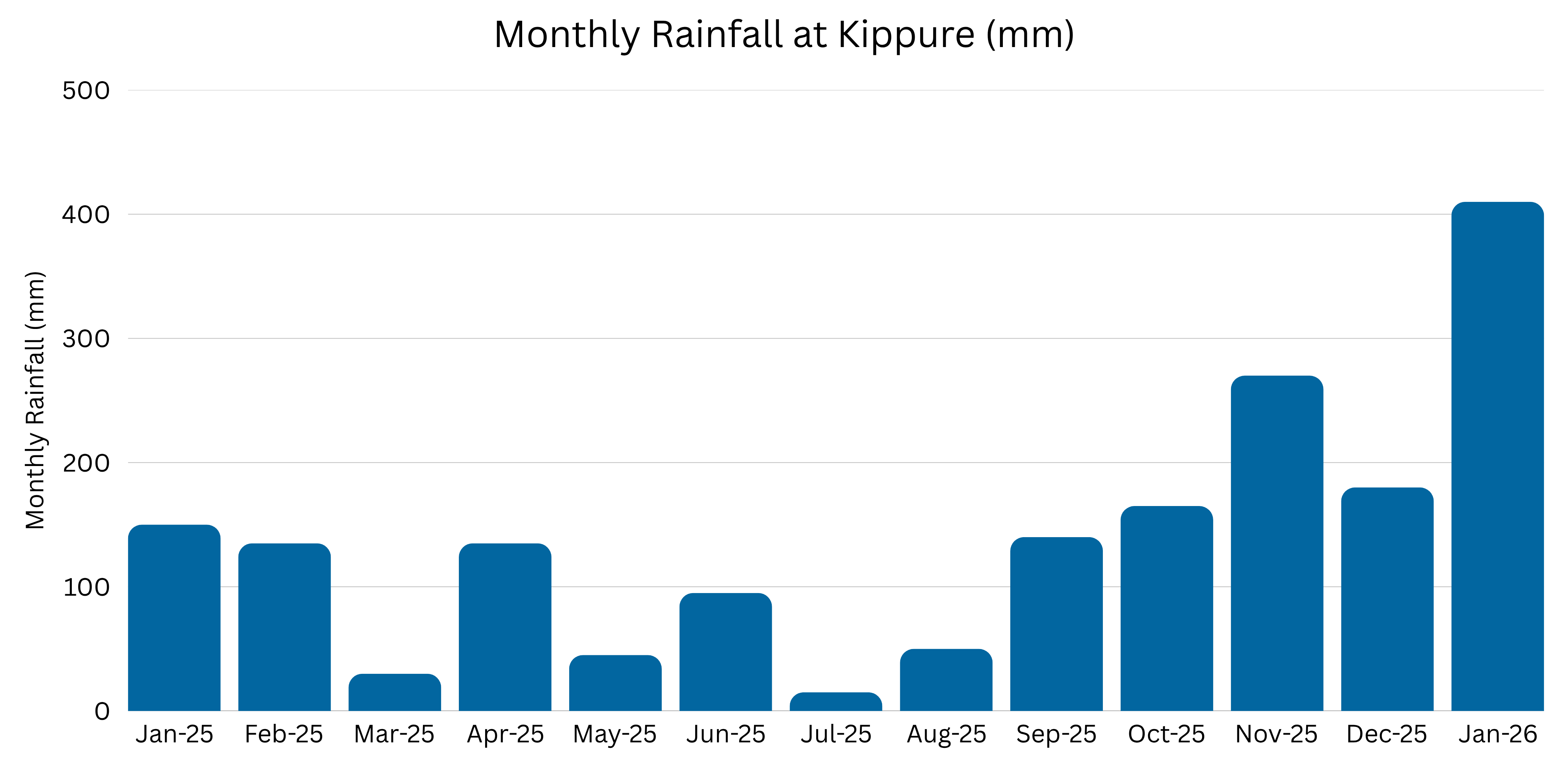
Figure 1: Monthly rainfall recorded at Kippure from Jan 25 to Jan 26
Rainfall totals recorded during January 2026 were significantly higher than much of the preceding year, contributing to increased river flows and reservoir inflows across the catchment.
Reservoir Storage and River Flows
The volume of inflows between 24th and 31st January caused reservoir levels at Poulaphouca to rise by two metres. During this period, only minimum flows were released from the reservoir, allowing available storage to be used to manage the peak inflows.
Without the storage capacity provided by Poulaphouca Reservoir, significantly larger volumes of water would have continued downstream through the River Liffey catchment into Kildare and Dublin, increasing river levels further along the system.
By retaining substantial volumes of water during the peak rainfall period, the reservoir helped reduce downstream river flows and mitigate flood risk in vulnerable areas.
The chart below shows daily rainfall recorded at Kippure alongside reservoir levels at Poulaphouca throughout January 2026, from the lowest recorded reservoir level on 16th January through to the sustained rainfall period beginning on 24th January
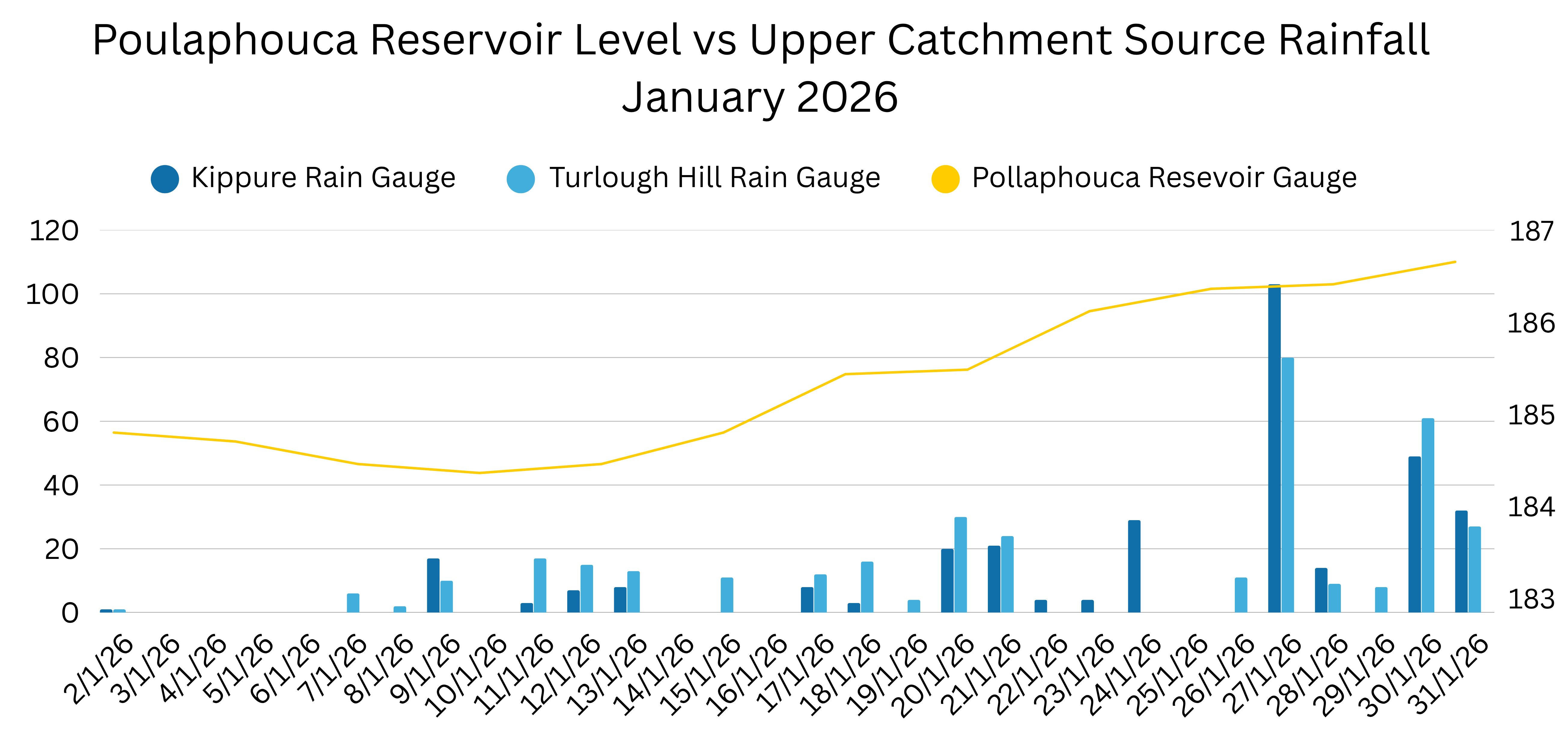
Figure 2: Poulaphouca reservoir level and Kippure rainfall across January 2026
Following sustained rainfall from 24th January onwards, inflows increased significantly and reservoir levels at Poulaphouca continued to rise through the peak rainfall period.
Reservoir Inflows and Outflows
Storm Ingrid arrived in Ireland on 24th January, with yellow rainfall levels forecast. It was followed by Storm Chandra on 26th January and a further yellow rainfall warning on 30th January. The runoff from this heavy rainfall flowed into the Liffey, and in the seven days from 24th to 31st January, approximately 45 billion litres of water flowed into Poulaphouca Reservoir. This is equivalent to around 18,000 Olympic-sized swimming pools.
Over the same period, approximately 8 billion litres of water were discharged downstream through Golden Falls.
The difference between these figures represents the substantial volume of water retained within the reservoir system during the event, significantly reducing peak flows downstream along the River Liffey.
It is important to note that, during this winter period, the preceding catchment conditions, rainfall amounts and available storage capacity at Poulaphouca allowed controlled discharges to the middle catchment, helping to mitigate flood risk. Rainfall across the middle catchment in Kildare was also not significant during this period. If the rainfall had been more intense, lasted longer, or fallen more heavily across the middle catchment, the downstream impacts of flows from Poulaphouca could have been more significant.
Downstream Monitoring and Coordination
River levels and flows are closely monitored across the River Liffey catchment, particularly downstream of Poulaphouca in low-lying areas such as Clane and Newbridge.
ESB continues to coordinate with local authorities, Met Éireann and relevant agencies to monitor rainfall forecasts, reservoir levels and downstream river flows.
Updated hydrometric information, including river levels and discharges at Golden Falls and Leixlip, is published daily on the ESB Hydrometric Information Website.
Poulaphouca Reservoir continues to play a critical role in managing river flows within the River Liffey catchment during periods of sustained rainfall.